
QUICK FACTS
Name: “Folded rocks” of the Aladaghlar Mountains
Location: Northwest Iran
Coordinates: 37.126276036681965, 47.61930020667193
Why it’s incredible: The landscape looks crumpled and folded from above.
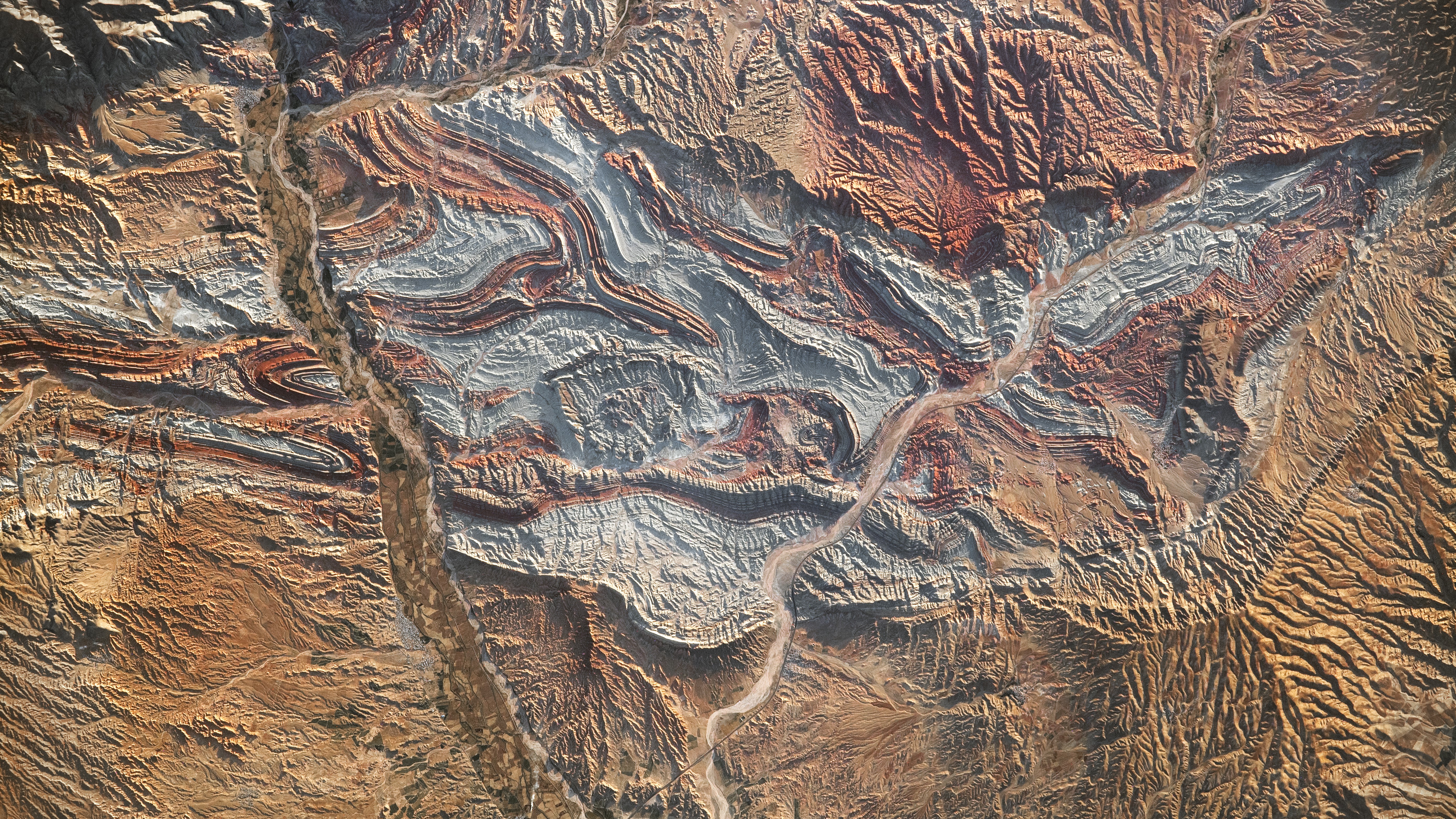
Iran’s folded rocks are rugged mountain ridges and valleys to the southwest of the Caspian Sea. They are an extension of the Greater Caucasus mountain belt, which also stretches along Russia’s border with Georgia and Azerbaijan.
The folded rocks sit at the intersection of Asia and Europe, where major tectonic forces converge. The rocks are formed of countless sedimentary layers, which were upturned and creased into the landscape we see today during the initial collision between the Arabian and Eurasian tectonic plates. The timing of this collision is hotly debated, with estimates ranging from 10 million to 50 million years ago.
“A tectonic collision between Eurasia and Arabia over millions of years compressed these colorful rock layers, bending them into large folds,” NASA officials wrote on the social platform X in January 2024.
The Arabian and Eurasian plates are still converging, and recent research indicates a chunk of oceanic crust that separated the two plates before they collided is now being torn apart under Iraq and Iran. The Neotethys oceanic plate appears to be pulling the region down from below, resulting in an unusual accumulation of sediment at the surface.
Related: North America is ‘dripping’ down into Earth’s mantle, scientists discover
Iran’s folded rocks are colorful, with vibrant terracotta, greenish and blueish bands that are the result of different sedimentary layers deposited over time. These layers were eroded over millions of years after the initial tectonic collision, exposing the underlying rocks’ alternating colors and textures.
Satellite images of the folded rocks reveal the extent to which the landscape was bunched together over the eons. Scientists at NASA’s Jet Propulsion Laboratory colored one such image with infrared to show the various rock layers, as well as vegetation and the human-built Zanjan-Tabriz freeway, which cuts through the folded rocks and connects the cities of Tehran and Tabriz.
Another satellite image from NASA’s Earth Observatory highlights the intricacy of Earth’s surface in this region and shows the Qezel Ozan River, which hugs the southeast corner of the folded rocks and supplies water for agriculture in the area.
Discover more incredible places, where we highlight the fantastic history and science behind some of the most dramatic landscapes on Earth.