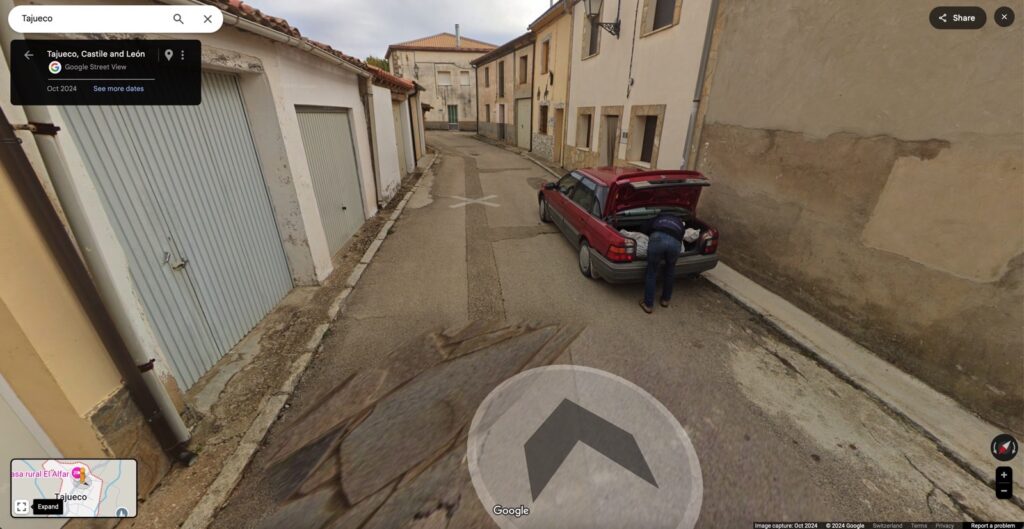
I use Street View features in Google Maps all the time to navigate new locations. It’s an easy way to see your destination before you get there and helps you familiarize yourself with the neighborhood you’re about to visit. It’s an incredible tool to have, especially considering that Google’s cars keep roaming the streets of the world to update the Street View data with new information.
Maybe the streets have changed, or new buildings have gone up in a region since the last time Google’s cars were photographing it for navigation purposes. Or perhaps an alleged murderer was finishing up loading up the body of a person in the trunk of a car just as a Google Maps Street View car drove by.
Ok, the last one is a rather wild claim and something you don’t see too often. But police in Spain think the scene caught by the Google car cameras above shows one of the persons involved in a conspiracy to murder someone. The suspect is arranging what appears to be a rather large package in the trunk of their car.
According to El Pais, the scene above happened in Tajueco, a village of only 56 people in the Soria province of Spain.
Google Maps cars did not visit the region for 15 years until one day last October. That’s when the cameras caught what appears to be a man arranging what seems to be “a long white bundle with a suspiciously human shape.”
Once I loaded the village of Tajueco in Google Maps, the scene wasn’t difficult to find. Looking at the images, it seems that the Google Maps vehicle turned left on the street where the red car was parked, passed the man hunched over the trunk, and went on its way.
One has to wonder whether the alleged killer realized what was happening. The Google Maps cars are anything but inconspicuous.
If you’re aware of how Google Maps and Street View work, you’d know you’ve been caught on camera. That’s assuming you can pay attention to anything else around you while dealing with an alleged body that might be decomposing in those bags. Yeah, the story gets way creepier.
Police have used other information to identify and arrest the two suspects. In addition to the image above, they also had cell phone messages and other evidence. Also, there’s a different Street View image of a person carrying “a large white bundle in a wheelbarrow.” I couldn’t find that image while virtually visiting the town of Tajueco.
The two suspects were formerly married. They’re believed to have killed a Cuban national at some point in November 2023, about a year before their arrest. The police charged them after the Google Maps images went up.
The investigation started when a relative of the victim reported him missing. Police told them that the man had sent the relative a WhatsApp message claiming they’d met a woman and would leave Soria. The man also said he would leave his phone behind.
The man is believed to have had a relationship with the now-arrested woman before he was murdered. It’s unclear why the former couple might have killed the Cuban.
The police are also investigating what happened between November 2023, when the victim disappeared, and October 2024, when Google cars visited the village.
Earlier this month, the police found a dismembered “torso in an advanced state of decay” in a cemetery in a different part of Soria. The location of other body parts has not been found. Apparently, the Cuban was very corpulent, prompting people to wonder what the alleged killers did with his body.
As I said, this murder case is terrifying. The only reason we’re paying attention to it right now is the involvement of Google Maps imagery, which remains online at the time of this writing. Check out the full El Pais report at this link.


