On a map, Cape Kumukahi might stand out at first for being the easternmost point of Hawai’i. But it’s not just geographically significant—the location appears prominently in ancient Hawaiian legends.
The Hawaiian word Kumukahi can be translated into English as “first beginning” or “origin.” Two specific legends are associated with Cape Kumukahi. First, it is recognized as the place where a group of gods traveling from Tahiti led by a god named Kumukahi landed in Hawai’i. The site once featured two stones named Ha‘eha‘e (after Kumukahi’s wife) and Makanoni (Ha‘eha‘e’s sister) that, when viewed looking towards the ocean, would mark the locations where the Sun rises during the summer and winter solstices. The legends described the two women as pushing the Sun back and forth between them.
The second legend describes how the cape was named after a chief named Kumukahi who ruled over a village in this location. The chief was competing in holua races when he mocked a woman who turned out to be the volcano goddess Pele in disguise. Pele retaliated by wiping out his village with a lava flow that also resulted in the formation of the cape. Today, a location near the cape features the rectangular base of a heiau (ancient Hawaiian temple) that was built in the 1500s and used until ancient Hawaiian spiritual practices were banned in 1819. The heiau is just one of the human-made structures at Cape Kumukahi.
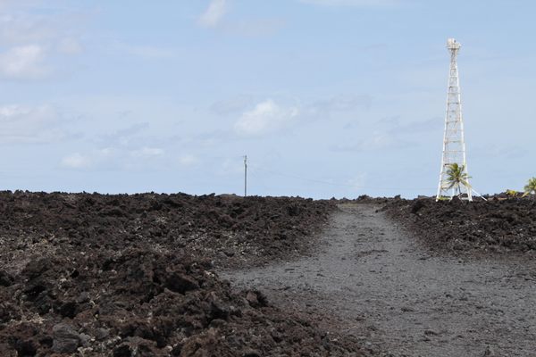
Cape Kumukahi’s first lighthouse, which was relatively short and had a relatively weak beacon, was constructed here in 1928, then replaced with a much taller lighthouse in 1934. This lighthouse consists of a utilitarian, modern-looking 125-foot-tall skeletal structure that has been painted white to help it stand out against the landscape.
Multiple lava flows have affected the area around the lighthouse. An eruption in 1955 came close enough to the station that the lighthouse tender’s life was considered at risk, even though the flow only came within a couple of miles of the site. In 1960, another major flow overran the site and destroyed most of the surrounding buildings, but the lava did not reach the lighthouse itself. You can still see the volcanic rock from the 1960 flow surrounding the structure today.
Another eruption in 2018 brought more change to the area. Part of the flow from that eruption cut off the access road to the lighthouse. While it didn’t affect the operation of the lighthouse itself, as it was fully automated after the 1960 eruption, the eruption did make the lighthouse more isolated. Some of the lava from the eruption flowed into the ocean south of Cape Kumukahi. Portions of the lava flow exploded and became fine black particles that were deposited on the shoreline south of Cape Kumukahi, forming a new black sand beach.
New eruptions in the future will certainly alter the landscape more around the cape, but for now, the lighthouse still stands among the lava fields as a survivor of one of the most destructive forces in nature.
Know Before You Go
Cape Kumukahi is about 22 miles southeast of Hilo, the largest city on the Big Island of Hawai’i. The closest town is Pahoa, which is nine miles away. To reach the site, visitors first need to drive from Pahoa to the end of Kapoho Road, park at the end of the road there, and then walk across the rock from the 2018 lava flow and down the original lighthouse access road to reach the cape. The hike to the lighthouse itself is about two miles and can be done in about 40 minutes.
Note that the lava rock is quite rough and may be jagged or sharp. Good hiking shoes are recommended. The hike is not recommended for people with limited mobility. Additionally, note that Cape Kumukahi has no visitor facilities and that the beach has no lifeguards.


